Reference Maps: Regular maps showing cities, boundaries, mountains, or roads
TIME ZONES
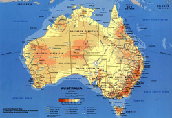
This is also a good time to take a look at time zones around the world. If you refer back to the map above, you can see the different time zones in the various colors. Since the earth rotates 360 degrees in a 24 hour period, the earth rotates 15 degrees every hour. In an ideal world, each time zone would follow lines of longitude every 15 degrees (7.5 degrees in each direction from the center of the time zone). But because of political boundaries, time zones are not divided up so perfectly and vary greatly in shape and width.
Greenwich, England was chosen in the mid-nineteenth century as the starting point of time worldwide. The reason was because at the time, England was the superpower of the time both militarily and economically. So the meridian that ran through Greenwich became zero degrees or the prime meridian. Because of the earth’s rotation in reference to the prime meridian, locations east of the new meridian meant time was ahead while locations west of the meridian were behind in time in reference to Greenwich, England.
Ultimately, when you combine parallel and meridian lines, you end up with a geographic grid system that allows you to determine your exact location on the planet.
LATITUDE AND LONGITUDE
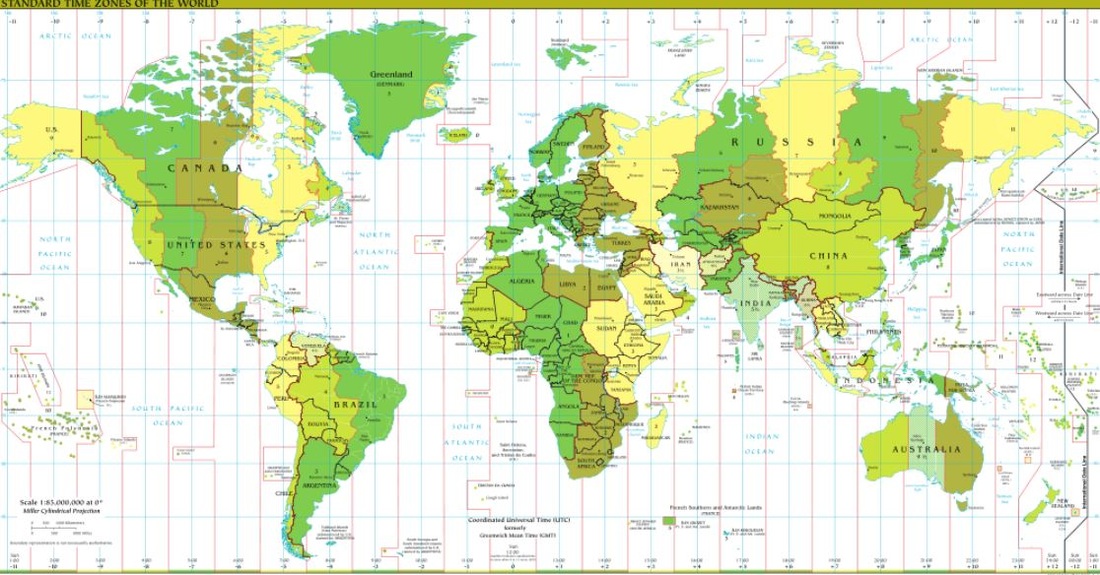
Many think that latitude is a line connecting points on the earth and it's not. Latitude is actually an angular measurement north or south of the equator (image on the left). So 30 degrees north means a point that is 30 degrees north of the equator. Latitude is also expressed in degrees, minutes, and seconds; 360 degrees in a circle, 60 minutes ( ' ) in a degree, and 60 seconds ( " ) in a minute. When you use Google Earth, the coordinate locations are in this degrees/minutes/seconds format. Latitude varies from 0 degrees (equator) to 90 degrees north and south (the poles).
A line connecting all points of the same latitude is called a parallel, because the lines run parallel to each other. The only parallel that is also a great circle is the equator. All other parallels are small circles. The following are the most important parallel lines:
At 180 degrees of the Prime Meridian in the Pacific Ocean is the International Date Line. The line determines where the new day begins in the world. Now because of this, the International Date Line is not actually a straight line, rather it follows national borders so that a country isn't divided into two separate days (and we think hour time zones are a pain). If you look at the map above, the International Date Line is to the right in a dark, black line. Note how it is drawn to make sure nations are not divided by the International Date Line.
Many think that latitude is a line connecting points on the earth and it's not. Latitude is actually an angular measurement north or south of the equator (image on the left). So 30 degrees north means a point that is 30 degrees north of the equator. Latitude is also expressed in degrees, minutes, and seconds; 360 degrees in a circle, 60 minutes ( ' ) in a degree, and 60 seconds ( " ) in a minute. When you use Google Earth, the coordinate locations are in this degrees/minutes/seconds format. Latitude varies from 0 degrees (equator) to 90 degrees north and south (the poles).
A line connecting all points of the same latitude is called a parallel, because the lines run parallel to each other. The only parallel that is also a great circle is the equator. All other parallels are small circles. The following are the most important parallel lines:
- Equator, 0 degrees
- Tropic of Cancer, 23.5 degrees N
- Tropic of Capricorn, 23.5 degrees S
- Arctic Circle, 66.5 degrees N
- Antarctic Circle, 66.5 degrees S
- North Pole, 90 degrees N (infinitely small circle)
- South Pole, 90 degrees S (infinitely small circle)
- Low latitude - generally between the equator and 30 degrees N
- Mid-latitude - between 30 degrees and 60 degrees N and S
- High latitude - latitudes greater than about 60 degrees N and S
- Equatorial - within a few degrees of the equator
- Tropical - within the tropics (between 23.5 degrees N and 23.5 degrees S
- Subtropical - slightly pole-ward of the tropics, generally around 25-30 degrees N and S
- Polar - within a few degrees of the North or South Pole
At 180 degrees of the Prime Meridian in the Pacific Ocean is the International Date Line. The line determines where the new day begins in the world. Now because of this, the International Date Line is not actually a straight line, rather it follows national borders so that a country isn't divided into two separate days (and we think hour time zones are a pain). If you look at the map above, the International Date Line is to the right in a dark, black line. Note how it is drawn to make sure nations are not divided by the International Date Line.
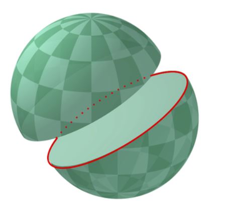
GREAT AND SMALL CIRCLES
Much of Earth's grid system is based on the location of the North Pole, South Pole, and Equator. The poles are an imaginary line running from the axis of Earth's rotation. The plane of the equator is an imaginary horizontal line that cuts the earth into two equal halves. This brings up the topic of great and small circles. A great circle is any circle that divides the earth into a circumference of two equal halves. It's also the largest circle that can be drawn on a sphere. The line connecting any points along a great circle is also the shortest distance between those two points. Examples of great circles include the Equator, all lines of longitude, the line that divides the earth into day and night called the circle of illumination , and the plane of ecliptic, which divides the earth into equal halves along the equator. Small circles are circles that cut the earth, but not into equal halves. Examples of small circles include all lines of latitude except the equator, the Tropical of Cancer, Tropic of Capricorn, the Arctic Circle, and Antarctic Circle.
Much of Earth's grid system is based on the location of the North Pole, South Pole, and Equator. The poles are an imaginary line running from the axis of Earth's rotation. The plane of the equator is an imaginary horizontal line that cuts the earth into two equal halves. This brings up the topic of great and small circles. A great circle is any circle that divides the earth into a circumference of two equal halves. It's also the largest circle that can be drawn on a sphere. The line connecting any points along a great circle is also the shortest distance between those two points. Examples of great circles include the Equator, all lines of longitude, the line that divides the earth into day and night called the circle of illumination , and the plane of ecliptic, which divides the earth into equal halves along the equator. Small circles are circles that cut the earth, but not into equal halves. Examples of small circles include all lines of latitude except the equator, the Tropical of Cancer, Tropic of Capricorn, the Arctic Circle, and Antarctic Circle.
1B.2: Use landscape analysis to examine the human organization of space.
LANDSCAPE ANALYSIS (e.g., field observations, photographic interpretations) provides a context for understanding the location of people, places, regions, and events; human-environmental relationships; and interconnections between and among places and regions.
One organization that is using LANDSCAPE ANALYSIS is the World Health Organization (part of the United Nations). They are mapping and analyzing the topography (shape of the land), soil analysis, etc., in order to determine how to increase the nutritional level especially for children. From their site it says: "The Landscape Analysis focuses on countries with high level of chronic undernutrition. Initially, the 36 high-burden countries* identified by the Lancet Nutrition Series (January 2008) to be home to 90% of the world's stunted children. However more recently additional countries have undertaken in-depth country assessments."
AP Focused Response Question (2003, #2)